Latest Entries »

This is the third and final post in a 3-part series discussing a partnership I initiated between Tulane University, the American Red Cross, and OpenStreetMaps, in which students in my undergraduate IDEV4100: ICT4D course participated in real-world mapping for OpenStreetMaps using satellite imagery, to support development and disaster preparedness initiatives being conducted by the American Red Cross in coordination with local host Red Cross and Red Crescent National Societies.

Outcomes Beyond the Base Maps

For Robert Banick, GIS analyst at the American Red Cross, through our emails and conversations, I know that at times fitting our class sessions into his schedule could be challenging, though we tried to be as flexible as possible, his travel schedule was often demanding. This also meant that his ability to Skype with our class could be challenging, particularly when he was in the field with one of his partner countries, such as when he was working in Chile or Nepal, and we were faced with spotty Internet access and connectivity issues on his end, which compounded some of the troubleshooting issues we were having with software, when one of our technical advisors became less accessible… though it did make for some teachable moments! Another complication was that I could never be certain too far in advance what the exact number of students enrolled would be, which made it difficult to tell how many students we could have working on a particular map, in turn complicating his decision-making somewhat. In addition, I couldn’t guarantee an extended amount of time for the students to spend on the project, because of the other scheduled assignments and to ensure respect for student time, I tried to make sure they knew what kind of time commitment was expected from them in advance. Robert was therefore managing a formula of X number of students times Y amount of time = Z volume of work, while fitting into one of the current needs of his partner Red Cross or Red Crescent National Societies.

Screen Shot 2016-03-16 at 5.12.56 PM

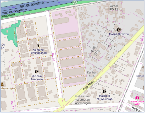
Figure I: Close-Up View of North Jakarta in OSM, February 2015

It is most evident that the students’ work continues to be built upon in Indonesia, when you look at the state of the maps in Jakarta and Depok now, nearly two years later. The maps there have continued to be updated by local volunteers in subsequent stages of the project, with street names and the addition of symbols indicating types of buildings such as mosques and hospitals. (see Figure I) Based on my conversations with him since then, most of the maps our students generated have been used, though unfortunately some have yet to be utilized (I suspect those that haven’t been utilized yet were those in Nepal, based on the limited progress the students made on those maps before they were pulled onto the Haiti project). But according to Robert, “that’s to be expected with a novel pilot approach like this.” View full article »

Advertisement

This is the second post in a 3-part series discussing a partnership I initiated between Tulane University, the American Red Cross, and OpenStreetMaps, in which students in my undergraduate IDEV4100: ICT4D course participated in real-world mapping for OpenStreetMaps using satellite imagery, to support development and disaster preparedness initiatives being conducted by the American Red Cross in coordination with local host Red Cross and Red Crescent National Societies.

A New Link in the Chain: Tulane Students Generate Maps

I got wind of a ‘mapping party‘the American Red Cross was hosting in August 2012, to jump-start their base maps for Prepare Uganda. The event was held in partnership with Humanitarian Open Street Maps (HOTOSM), who also hosted the data, and little to no previous experience was required on the part of the volunteers. More than 20 volunteers joined the mapping party in person on August 19th and traced streets, paths, parks, and other points of interest from the satellite images into Open Street Maps, a freely editable wiki map. These base maps would then move to the next stage of editing by local volunteer teams on the ground in Uganda using geographic surveys to fill in details like street names and building uses to take the maps to the next level.

The idea of participants needing little to no previous experience was surprising, yet appealing me to. If a one-time event like this with approximately two dozen volunteers could produce a workable product for this kind of project, what might a classroom of university students do in a couple of weeks with some training and support? An idea occurred to me that we might have an opportunity for a “win-win” situation: by partnering with the International Services Department staff at American Red Cross NHQ who were working on the mapping projects, our Tulane students might be able to generate an incredible quantity of base-level mapping work for their OSM project, while at the same time gaining some valuable hands-on learning experience with a real-world technology-based project. It was a new kind of model: a short-term group of crowdmappers with training specific to their project area, focusing on one geographic area, based on a particular need. I contacted the GIS analyst at the American Red Cross who was heading up the project, Robert Banick, and pitched the idea to him. It was an appealing addition from his perspective as well, a somewhat “captive” group of mappers to work on a specific project at a known time. There was an additional space in Braise, Uganda that he and his colleagues in the field were hoping to have a base map available for within the next few months, so students enrolled in the Fall 2012 course offering could fill a definite short-term need for their program.

Just as the Fall 2012 semester was beginning, I quickly modified the course syllabus, adjusted some assignments and timelines in order to accommodate this exciting project opportunity, endeavoring to best match Robert’s needs and schedule as well as the students’ needs and semester schedule. We settled on an “end of semester” project, for late November/early December, to fit Robert’s travel schedule, the needs of the Bwaise local mapping teams, and to give us time to develop our plans for working with the students, while also allowing me to replace the students’ final project for the course with a hands-on OSM learning activity. View full article »

This is the first in a 3-part series of posts discussing a partnership I initiated between Tulane University, the American Red Cross, and OpenStreetMaps, in which students in my undergraduate IDEV4100: ICT4D course participated in real-world mapping for OpenStreetMaps using satellite imagery, to support development and disaster preparedness initiatives being conducted by the American Red Cross in coordination with local host Red Cross and Red Crescent National Societies.

Background

The American Red Cross International Services Division, in partnership with Red Cross and Red Crescent National Societies in developing countries, helps enhance disaster preparedness programming in part by coordinating the development of improved base maps, in partnership with Humanitarian OpenStreetMap, to provide more reliable information for first responders to utilize in the event of floods, fires, or other natural disasters.

This paper explores the process of Tulane University students becoming involved with Red Cross and OpenStreetMap, the tangible outcomes of this work, benefits and challenges involved with coordinating and executing these short-term mapping projects, the assigning and grading of this coursework, and feedback from participating students. Lessons learned and best practices for university courses, and implications for digital social innovation activities of this type are discussed. In order for these efforts to be successful, they needed to meet objectives on both ends. For the students and the course, the activity would need to meet learning objectives and provide an opportunity for students to engage with concepts they encountered in their classroom. For the Red Cross partners, it needed to at least have the potential to generate a volume and quality of work that would be beneficial to them as they entered the next phase of mapping. View full article »

During my field observations of the brown bears, I have had very little opportunity to observe parents and offspring interacting, with the exception of one instance, in my post on Momma & Baby Bears. However, as I mentioned recently, Explore.org, the group responsible for hosting the live cameras, also provides a handful of highlight videos from this year and past years, which allows viewers to see footage of different activities they are less likely to stumble upon via the live feeds. In order to learn more about the parent/offspring interaction, I utilized one of their highlight videos, entitled “402 Reunites with Her Missing Cub”. In this video, which is quite short (only slightly longer than 2 minutes), we see a relatively small bear cub by itself at the beginning of the video, which sits on the side of an embankment and seems to call out a few times. Shortly thereafter we see the momma bear arrive and the two are reunited.

More on mother bear and cub interaction to come…

Today was an exciting day of bear watching! I actually had just turned on the bearcams to show my husband what I had been doing for my field observations, and when I pulled up the second camera at the Lower River, I was shocked to see a momma bear and two baby bears in the river! So a casual glimpse at the bearcams turned into a real field observation quite quickly! This was the first and only time I have been able to see a live shot of baby bears during my time watching the cameras at Katmai.

When I first saw the baby bears, they just looked like little bumps in the water behind the larger bear. Momma bear (I will refer to her as Bear M) is mostly blonde in color, with large ears and a smallish head. She doesn’t seem particularly large, perhaps because much of her fishing catches go to her offspring rather than feeding herself. The baby bears – I believe there were only two, though there may have been three – have fur that is darker in color than the momma bear, they are a dark brown color.

IMG_0083

Momma Bear M and two baby bears in the water at the Lower River.

View full article »

Thus far in my field observations I haven’t been able to observe personally any kind of mating behavior via the live webcams available at the Katmai National Park. However, Explore.org, the group responsible for hosting the live cameras, also provides a handful of highlight videos from this year and past years, which allows viewers to see footage of different activities they are less likely to stumble upon via the live feeds. I found one such video, a highlight video entitled “Bear 856 Pursues Female Bear 410 at Brooks Falls, Alaska”, which provided a small glimpse of some of the brown bear mating behavior . It’s a relatively short clip, less than two minutes in length, and shows the male bear 856 following female bear 410 as she walks around Brooks Falls. He walks into the frame from the right side, she makes her way toward the far bank, and begins to move more quickly downstream, almost running. He pursues her back upstream, around the small sandbar, back to the fall pool, up over the falls, toward the foreground and along the lip, before the clip ends. Their pace is never very fast, although at times she seems to scramble a bit and pick up her pace.

More on brown bear mating behavior to come…

Another day of watching the brown bears fish at Brooks Falls at Katmai National Park, on the live bearcam they have set up there. As I’ve mentioned before, this bearcam is set up at the same location as a wooden platform that is physically available for visitors of the park to stand and watch the bears fish live in person. This image, taken from the Google maps photo uploads, shows exactly how close the platform is to the falls, and how close the park visitors can get to where the bears are fishing:

Screen Shot 2015-07-17 at 3.29.14 PM

The visitor’s platform at Brooks Falls, Katmai National Park

This leads me to wonder how this proximity to humans might affect the food-gathering/fishing habits of the bears here at Brooks falls. As I’ve wondered in a previous post, it’s possible that bears less comfortable with the human presence might stay in the far pool to fish, or indeed, may not come to these falls to fish at all, but might prefer other, less desirable fishing spots along the river that are less likely to be visited by humans. I’ve noticed, when the sound is working on the cameras, that the visiting humans will tend to cheer when a bear catches a fish, similar to spectators watching s sports match. This could be distracting to the bears, or intimidating to them, or affect them in some other way. Bears more comfortable with the human presence might be more likely (or more able) to fish at the spots on the falls that are closer to the visitor’s platform, namely at the lip or the jacuzzi spots. These also seem to be the spots where bears are more likely to catch fish, in my observations. I have seen more bears catch fish (or bears catch more fish) at these locations than bears at the far pool or in the space between the jacuzzi and the far pool.

View full article »

While the Brooks Falls webcam at Katmai National Park is more popular and seems to have a great deal more activity on a daily basis in terms of brown bear-watching, I was determined to find some bears at the other cam, downriver at the mouth of Brooks River, at the Lower River webcam. After several days of checking in there, I finally caught a glimpse of a bear there for enough time to feel like it was worth including here. Following my previous conventions, I’ll refer to this bear as Bear G.

First, a note about the Lower River webcam. While the Brooks Falls webcam seems to focus almost exclusively on the Falls themselves, with an occasional pan to the right to see downstream a bit, the Lower River webcam covers a much wider area near the mouth of the Brooks River. It seems to pan across an almost 360-degree space, including the mouth of the river, a pedestrian bridge crossing the river, and a somewhat marshy-looking area of the river banks with taller grasses, a bit farther upriver from the mouth. Depending on the time of day and the amount of activity in each spot, the camera could be focused on any of these areas, or somewhere in between. There definitely seems to be an “operator” of some kind who monitors the camera, panning and zooming based on when there are bears or other interesting things present, and moving the camera to different views of the river from time to time.

So… around 1:15pm local time today, I saw Bear G near the mouth of the Brooks River, walking across a small strip of land at the farthest point near the river’s mouth. Bear G is light brown to dark blonde in color, with a roundish-dish-shaped face, darker fur on its legs and chest, and a darker patch of fur on the back of its neck. It seems to have a slightly short, perhaps upturned snout, and seems a bit thinner and smaller than some of the other bears I’ve seen. No other distinguishing marks were visible due to the distance. Bear G walked along the narrow strip of land, sat at the end of the point of land for a moment or two, looked around, scratched itself behind the ear in much the way you would see a domestic dog scratch itself, then turned, walked back a bit, and went into the water away from the camera and began to swim off to the left. It would stop every so often and sort of get into a standing posture, look around, then go back into a swimming posture. After swimming off diagonally to the left a bit, it turned, swam directly right back toward the land, where it eventually came out of the water further to the right from where it had gone in, and began to walk back off to the right, off camera.

It wasn’t entirely clear to me what behavior the bear was demonstrating here. It may have been foraging for fish (though it did not catch any if it was fishing), may have been looking for another bear, may have been performing some kind of recreational activity (just swimming for fun), or something else.

Screen Shot 2015-07-08 at 4.16.10 PM Screen Shot 2015-07-08 at 4.16.40 PM Screen Shot 2015-07-08 at 4.20.27 PM Screen Shot 2015-07-08 at 4.20.34 PM Screen Shot 2015-07-08 at 4.24.09 PM Screen Shot 2015-07-08 at 4.24.14 PM

After my last post, later that same evening, I was able to witness a bit more fishing activity at Brooks Falls, again at the Brooks Falls Live Cam. I only watched for a short time, and while there were two bears present, I focused on one, witnessing some interesting behavior in terms of the way it handled the fish it caught. Following my pattern, I will refer to this bear as Bear F. Bear F is of a dark blonde to light brown color throughout most of its coat, with lighter blonde on the ears and a darker brown on the legs. It seems to have a somewhat more pronounced brow than some of the other bears I have seen, a roughly average-length snout, and some possible scarring on the left front shoulder (difficult to tell given the resolution of the video).

Bear F was fishing at the lip at Brooks Falls as I watched. What was most interesting about it’s behavior was that after catching a fish and moving to the nearby flatter rock to eat the fish (a common enough behavior for those bears that fish at this spot), Bear F only seemed to eat part of the fish before going back to the lip to continue fishing, not eating all of the fish. I’m not sure if this is common, but the other bears I’ve seen have largely seemed to eat most or all of the fish they’ve caught before going to catch another. Once Bear F moved back to the lip to catch more fish, some nearby birds arrived almost immediately and began foraging on the fish carcass, eating the meat leftover from Bear F’s catch, until the fish fell over the falls. Bear F caught another fish within a matter of moments and went on to eat that one as well. Perhaps the amount of meat left on the first fish in comparison to the inedible parts of the fish wasn’t worth the time the bear would spend picking apart, in comparison to the time it took to catch another fish. Time was better spent fishing and obtaining the next meaty fish rather than scrounging for every last bit of meat left on the first one? This seems to work out well for the birds, and Bear F didn’t seem to mind the birds swooping in on the fish.

Possible IDs: TBD

Screen Shot 2015-07-07 at 11.30.39 PMScreen Shot 2015-07-07 at 11.31.01 PMScreen Shot 2015-07-07 at 11.33.46 PM Screen Shot 2015-07-07 at 11.55.35 PM Screen Shot 2015-07-07 at 11.34.20 PM

After my first attempt at field observation, I was a bit disappointed, so I hoped for a better experience today when I logged on to the Brooks Falls Live webcam to see if I was able to observe any brown bear activity. Katmai National Park is 3 hours behind my home in New Orleans (GMT -5:00), which puts it at GMT -8:00, so I planned my watching times accordingly. To my delight, I saw several different bears fishing at Brooks Falls today, observed many successful catches, and, frankly, became completely mesmerized by the bearcams. If you haven’t already checked them out, I highly recommend it. Almost any time I logged on throughout the day, I was able to see some bears. I’m going to focus my notes on three bears that I specifically saw fishing today, between approximately 10:45am and 11:35am local time at the Park. Unless (and until) I can identify their sex, I’ll refer to them as Bear C, Bear D, and Bear E.

Bear C at the Jacuzzi

Bear C arrived from the near bank of the Falls, and walked up along the bank and then into the river close to the falls, taking up a position in the jacuzzi. (Bear E can be seen in the background of the first photo, at the Far Pool, while Bear C is entering the river from the left side of the screen.) This bear seems relatively dark for this time of year, since most bears are lighter in the spring through July and become darker in the fall (though admittedly this could be because it was already wet), with a somewhat short snout, dish-shaped head and wide-set ears. The bear sat somewhat low in the water, it seemed, and ducked its head several times into the water in tandem with grabbing motions with its paws to attempt to catch fish. It caught at least two fish while I was watching it, staying at the jacuzzi for approximately 12 minutes before walking downstream in the water, with the second fish still in its mouth. If Bear C is female, this  second fish could be being taken to one or more cubs waiting downstream.

Possible IDs: #402, #218, #856

Screen Shot 2015-07-07 at 1.46.44 PM

Bear C entering the river at Brooks Falls from the near bank.

Screen Shot 2015-07-07 at 1.51.24 PM

Bear C in “the jacuzzi” as salmon can be seen leaping up the falls.

View full article »